Shopping cart
Your cart empty!
Your cart empty!
Terms of use dolor sit amet consectetur, adipisicing elit. Recusandae provident ullam aperiam quo ad non corrupti sit vel quam repellat ipsa quod sed, repellendus adipisci, ducimus ea modi odio assumenda.
Lorem ipsum dolor sit amet consectetur adipisicing elit. Sequi, cum esse possimus officiis amet ea voluptatibus libero! Dolorum assumenda esse, deserunt ipsum ad iusto! Praesentium error nobis tenetur at, quis nostrum facere excepturi architecto totam.
Lorem ipsum dolor sit amet consectetur adipisicing elit. Inventore, soluta alias eaque modi ipsum sint iusto fugiat vero velit rerum.
Sequi, cum esse possimus officiis amet ea voluptatibus libero! Dolorum assumenda esse, deserunt ipsum ad iusto! Praesentium error nobis tenetur at, quis nostrum facere excepturi architecto totam.
Lorem ipsum dolor sit amet consectetur adipisicing elit. Inventore, soluta alias eaque modi ipsum sint iusto fugiat vero velit rerum.
Dolor sit amet consectetur adipisicing elit. Sequi, cum esse possimus officiis amet ea voluptatibus libero! Dolorum assumenda esse, deserunt ipsum ad iusto! Praesentium error nobis tenetur at, quis nostrum facere excepturi architecto totam.
Lorem ipsum dolor sit amet consectetur adipisicing elit. Inventore, soluta alias eaque modi ipsum sint iusto fugiat vero velit rerum.
Sit amet consectetur adipisicing elit. Sequi, cum esse possimus officiis amet ea voluptatibus libero! Dolorum assumenda esse, deserunt ipsum ad iusto! Praesentium error nobis tenetur at, quis nostrum facere excepturi architecto totam.
Lorem ipsum dolor sit amet consectetur adipisicing elit. Inventore, soluta alias eaque modi ipsum sint iusto fugiat vero velit rerum.
Do you agree to our terms? Sign up
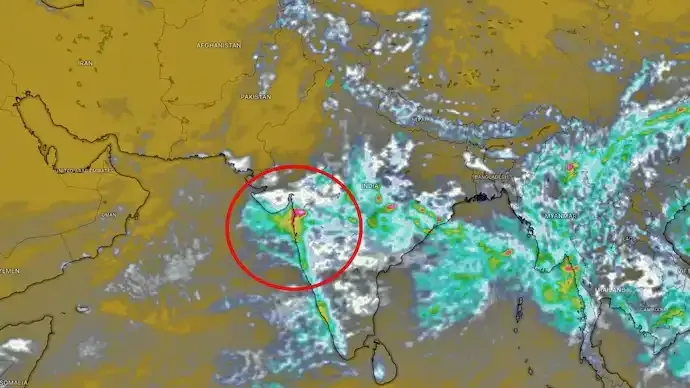
Mumbai is preparing for another round of intense monsoon showers after satellite imagery revealed a vast rain-bearing cloud system advancing from the Arabian Sea towards Maharashtra's coastline. Weather experts expect the developing system to bring heavy to very heavy rainfall across Mumbai and several neighbouring districts over the coming hours.
South Mumbai has already witnessed spells of intense rain, while meteorologists continue to monitor the rapidly evolving cloud formation using Indian and international weather satellites.
Fresh satellite observations captured on Friday morning show a dense cluster of monsoon clouds covering large parts of the east-central Arabian Sea.
According to meteorological observations, the cloud mass is steadily moving towards Maharashtra's western coast and has the potential to produce widespread rainfall.
The satellite imagery also indicates:
Meteorologists say the cloud tops visible in satellite images are extremely cold, a key indicator of powerful vertical cloud development.
Such cloud formations are generally associated with:
Deep convective clouds often produce intense rainfall over short periods, increasing the risk of urban flooding in low-lying areas.
The approaching weather system is expected to affect several parts of Maharashtra, particularly coastal districts.
Areas likely to experience heavy rainfall include:
Residents have been advised to stay updated with official weather advisories as rainfall intensity may vary throughout the day.
The southwest monsoon continues to remain active over western India, drawing abundant moisture from the Arabian Sea.
This moisture is interacting with favourable atmospheric conditions, leading to repeated spells of heavy rain across Maharashtra.
Meteorologists say such weather patterns are common during an active phase of the monsoon, when successive cloud systems move inland from the Arabian Sea.
If rainfall intensifies as forecast, Mumbai could witness temporary disruptions similar to previous heavy rain events.
Possible impacts include:
Authorities remain on alert to respond to any weather-related emergencies.
With heavy rainfall expected, residents are advised to take necessary precautions.
Safety measures include:
People living in flood-prone areas should remain especially vigilant.
Modern weather satellites such as INSAT-3DR provide real-time information about cloud movement, rainfall intensity and storm development.
These observations help meteorologists:
Satellite monitoring plays a crucial role in disaster preparedness during the monsoon season.
Satellite images have revealed a massive rain-bearing cloud system moving from the Arabian Sea towards Maharashtra. Weather experts expect heavy to very heavy rainfall across Mumbai and nearby districts as deep convective clouds increase the risk of thunderstorms, waterlogging and travel disruptions.
Mumbai remains under the influence of an active monsoon system as a large cloud mass advances from the Arabian Sea towards Maharashtra. With satellite imagery indicating favourable conditions for heavy rainfall and thunderstorms, residents should stay informed through official weather updates and take necessary precautions. As the southwest monsoon continues its active phase, weather agencies are expected to closely monitor rainfall intensity and issue timely advisories to minimise disruption and ensure public safety.
A massive rain-bearing cloud system over the Arabian Sea is moving towards Maharashtra, creating favourable conditions for heavy rain.
The images reveal extensive cloud cover with deep convective clouds capable of producing heavy rainfall and thunderstorms.
Mumbai, Thane, Palghar, Raigad and several parts of coastal Maharashtra are likely to receive heavy rainfall.
Cold cloud tops indicate strong vertical cloud development and are commonly associated with intense thunderstorms and heavy rain.
Yes. Waterlogging, traffic congestion, railway delays and possible flight disruptions may occur depending on rainfall intensity.
INSAT-3DR, along with global weather satellites, is tracking the cloud movement and rainfall activity.
People should avoid unnecessary travel, monitor official advisories and stay away from waterlogged areas during heavy rainfall.
Yes. The approaching cloud system is associated with the active southwest monsoon over western India.
2
Published: 1h ago

All India Story is your trusted source for comprehensive and up-to-the-minute news coverage across India. Bringing you the latest on politics, business, technology, entertainment, sports, and more, we are dedicated to keeping you informed with accurate, engaging, and insightful stories from every corner of the nation.