Shopping cart
Your cart empty!
Your cart empty!
Terms of use dolor sit amet consectetur, adipisicing elit. Recusandae provident ullam aperiam quo ad non corrupti sit vel quam repellat ipsa quod sed, repellendus adipisci, ducimus ea modi odio assumenda.
Lorem ipsum dolor sit amet consectetur adipisicing elit. Sequi, cum esse possimus officiis amet ea voluptatibus libero! Dolorum assumenda esse, deserunt ipsum ad iusto! Praesentium error nobis tenetur at, quis nostrum facere excepturi architecto totam.
Lorem ipsum dolor sit amet consectetur adipisicing elit. Inventore, soluta alias eaque modi ipsum sint iusto fugiat vero velit rerum.
Sequi, cum esse possimus officiis amet ea voluptatibus libero! Dolorum assumenda esse, deserunt ipsum ad iusto! Praesentium error nobis tenetur at, quis nostrum facere excepturi architecto totam.
Lorem ipsum dolor sit amet consectetur adipisicing elit. Inventore, soluta alias eaque modi ipsum sint iusto fugiat vero velit rerum.
Dolor sit amet consectetur adipisicing elit. Sequi, cum esse possimus officiis amet ea voluptatibus libero! Dolorum assumenda esse, deserunt ipsum ad iusto! Praesentium error nobis tenetur at, quis nostrum facere excepturi architecto totam.
Lorem ipsum dolor sit amet consectetur adipisicing elit. Inventore, soluta alias eaque modi ipsum sint iusto fugiat vero velit rerum.
Sit amet consectetur adipisicing elit. Sequi, cum esse possimus officiis amet ea voluptatibus libero! Dolorum assumenda esse, deserunt ipsum ad iusto! Praesentium error nobis tenetur at, quis nostrum facere excepturi architecto totam.
Lorem ipsum dolor sit amet consectetur adipisicing elit. Inventore, soluta alias eaque modi ipsum sint iusto fugiat vero velit rerum.
Do you agree to our terms? Sign up
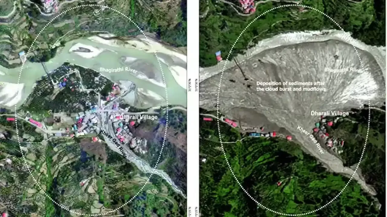
Fresh satellite imagery has revealed the formation of a temporary water pool upstream of the Dharali-Harsil stretch in Uttarkashi district, nearly a year after devastating mudflows dramatically altered the landscape of the Bhagirathi Valley. The latest development has sparked renewed concerns among local residents as the monsoon intensifies and river levels continue to rise.
Communities living along the Bhagirathi River have reported increasing river erosion, with swelling waters eating into riverbanks and threatening homes, public buildings, and essential infrastructure. The appearance of a water body behind debris deposited during the 2025 disaster has heightened fears of potential flooding if the temporary obstruction fails.
Recent satellite images captured over the Dharali-Harsil region show a newly formed water pool behind debris left by the massive mudflows that struck the valley in August 2025. The images indicate that water has begun accumulating upstream, suggesting that debris deposited during last year's disaster continues to influence the river's natural flow.
Experts often monitor such temporary water bodies closely because they can increase pressure on natural debris barriers. If these barriers weaken or collapse suddenly, downstream areas may experience rapid flooding.
Although the formation of temporary pools is not uncommon in mountainous terrain after landslides or mudflows, continuous monitoring becomes essential during the monsoon season when heavy rainfall can significantly increase water volume.
Residents in Harsil and nearby villages have reported noticeable changes in the Bhagirathi River over recent weeks. The river has expanded in several sections, gradually eroding its banks and moving closer to residential areas.
Several locations along the river corridor are witnessing accelerated erosion, raising concerns about the safety of nearby houses, roads, government facilities, and public utilities.
Local communities remain particularly cautious because many areas are still recovering from the destruction caused by last year's disaster.
On August 5, 2025, intense mudflows originating from the Tel Gad and Kheer Gad streams swept through the Harshil-Dharali region in Uttarkashi.
The powerful surge of mud, rocks, and debris caused widespread destruction, damaging homes, roads, and other infrastructure while significantly altering the course of the Bhagirathi River.
The disaster reshaped parts of the valley, leaving behind massive debris deposits that continue to affect river movement and drainage patterns nearly a year later.
Temporary water pools created behind landslide or mudflow debris can pose serious risks if not monitored carefully.
Some of the major concerns include:
As water continues accumulating, pressure on the natural debris barrier rises. A sudden breach could send large volumes of water downstream within a short period.
Higher water levels can accelerate erosion, weakening riverbanks and increasing the possibility of structural damage to nearby buildings and roads.
Roads, bridges, public buildings, and utility networks located close to the Bhagirathi River may face greater vulnerability if river levels continue to rise.
People living in low-lying areas near the river remain concerned about possible evacuation needs if heavy rainfall intensifies during the ongoing monsoon season.
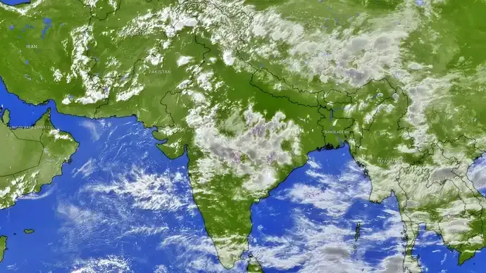
Satellite-based remote sensing has become an essential tool for tracking changes in fragile Himalayan landscapes.
Modern satellite imagery allows authorities and scientists to:
Regular observations can help identify emerging hazards before they become large-scale emergencies.
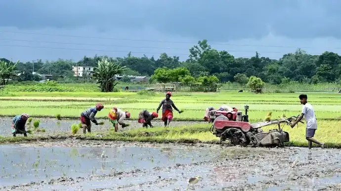
The Himalayan region experiences heightened geological activity during the southwest monsoon. Heavy rainfall often saturates mountain slopes, increasing the likelihood of landslides, mudflows, flash floods, and riverbank erosion.
When rivers carry additional sediment and debris, their channels may shift, creating new hazards for settlements located along their banks.
Experts continue to emphasize the importance of continuous monitoring, timely inspections, and preventive measures in vulnerable mountain districts.
People living in the Dharali-Harsil belt remain on alert as changing river conditions continue to affect daily life.
Many residents are worried about:
Community members are closely watching weather conditions while hoping that preventive measures reduce future risks.
Authorities typically monitor vulnerable river stretches during the monsoon using field inspections, satellite observations, rainfall data, and hydrological assessments.
Experts recommend continued surveillance of the newly formed water pool, regular evaluation of debris stability, and rapid response planning to minimize potential impacts if conditions deteriorate.
Satellite images have identified a newly formed water pool upstream of the Dharali-Harsil region in Uttarakhand's Uttarkashi district, nearly a year after the 2025 mudflow. Rising Bhagirathi River levels and ongoing erosion have raised concerns about flooding, infrastructure damage, and the need for continuous monitoring during the monsoon.
The discovery of a new water pool behind the debris left by the 2025 Dharali mudflow highlights the continuing impact of last year's disaster on Uttarakhand's fragile Himalayan landscape. With the Bhagirathi River rising once again during the monsoon, close monitoring of the area remains essential to assess evolving risks, protect vulnerable communities, and support timely disaster preparedness measures.
The temporary water pool has been identified upstream of the Dharali-Harsil stretch in Uttarkashi district, Uttarakhand.
It may increase flood risk if accumulated water breaches the natural debris barrier created during the 2025 mudflow.
The disaster was triggered by debris and mudflows originating from the Tel Gad and Kheer Gad streams, which reshaped the Bhagirathi River channel.
Satellite imagery helps monitor river changes, erosion, debris movement, and newly formed water bodies in difficult-to-access Himalayan terrain.
Yes. Residents have reported rising water levels and increased riverbank erosion in parts of the Harsil-Dharali valley.
Homes, roads, government buildings, bridges, and public utilities located near the riverbanks may face increased risk.
Yes. Heavy rainfall during the monsoon can increase water accumulation, erosion, and pressure on temporary debris barriers.
Continuous monitoring, timely inspections, early warning systems, and preparedness measures are essential to reduce potential disaster risks.
3
Published: 1h ago

All India Story is your trusted source for comprehensive and up-to-the-minute news coverage across India. Bringing you the latest on politics, business, technology, entertainment, sports, and more, we are dedicated to keeping you informed with accurate, engaging, and insightful stories from every corner of the nation.