Shopping cart
Your cart empty!
Your cart empty!
Terms of use dolor sit amet consectetur, adipisicing elit. Recusandae provident ullam aperiam quo ad non corrupti sit vel quam repellat ipsa quod sed, repellendus adipisci, ducimus ea modi odio assumenda.
Lorem ipsum dolor sit amet consectetur adipisicing elit. Sequi, cum esse possimus officiis amet ea voluptatibus libero! Dolorum assumenda esse, deserunt ipsum ad iusto! Praesentium error nobis tenetur at, quis nostrum facere excepturi architecto totam.
Lorem ipsum dolor sit amet consectetur adipisicing elit. Inventore, soluta alias eaque modi ipsum sint iusto fugiat vero velit rerum.
Sequi, cum esse possimus officiis amet ea voluptatibus libero! Dolorum assumenda esse, deserunt ipsum ad iusto! Praesentium error nobis tenetur at, quis nostrum facere excepturi architecto totam.
Lorem ipsum dolor sit amet consectetur adipisicing elit. Inventore, soluta alias eaque modi ipsum sint iusto fugiat vero velit rerum.
Dolor sit amet consectetur adipisicing elit. Sequi, cum esse possimus officiis amet ea voluptatibus libero! Dolorum assumenda esse, deserunt ipsum ad iusto! Praesentium error nobis tenetur at, quis nostrum facere excepturi architecto totam.
Lorem ipsum dolor sit amet consectetur adipisicing elit. Inventore, soluta alias eaque modi ipsum sint iusto fugiat vero velit rerum.
Sit amet consectetur adipisicing elit. Sequi, cum esse possimus officiis amet ea voluptatibus libero! Dolorum assumenda esse, deserunt ipsum ad iusto! Praesentium error nobis tenetur at, quis nostrum facere excepturi architecto totam.
Lorem ipsum dolor sit amet consectetur adipisicing elit. Inventore, soluta alias eaque modi ipsum sint iusto fugiat vero velit rerum.
Do you agree to our terms? Sign up

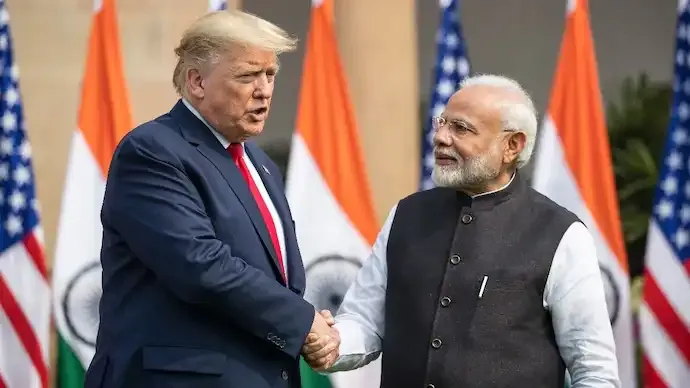
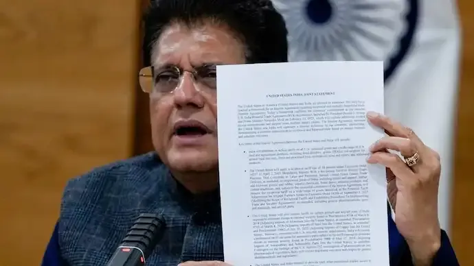
The announcement of the interim India-US trade framework has drawn attention not only for its economic implications but also for a map released alongside the agreement that has triggered geopolitical discussions. The visual depiction, shared by the US trade representative’s office, showed the entire region of Jammu and Kashmir — including Pakistan-occupied Kashmir and Aksai Chin — within India’s boundaries, prompting widespread reactions online.
While India has consistently maintained that Jammu and Kashmir is an integral part of the country, the map’s presentation is being viewed as a notable shift in tone compared to earlier representations released by US agencies. Historically, several official maps from international institutions included demarcations or disputed markings around the region. The latest version, however, displayed a unified territorial outline without separate markings that aligned with Pakistan’s claims.
Observers note that the timing of this development is significant, as it coincides with efforts by New Delhi and Washington to reset economic and strategic cooperation through the interim trade pact. The agreement focuses on tariff adjustments, improved market access, and stronger collaboration in technology and supply chains, but the map has become an unexpected talking point in diplomatic circles.
The depiction also included Aksai Chin, a region at the centre of India-China territorial disagreements. For years, India has objected to international maps that it believed misrepresented its borders, particularly in Jammu and Kashmir and Arunachal Pradesh. The new map has therefore been interpreted by some analysts as reflecting a greater sensitivity toward India’s long-standing concerns regarding territorial representation.
Geopolitical commentators have highlighted that the visual messaging may indicate evolving diplomatic dynamics in South Asia. The United States has historically attempted to maintain a balanced approach toward regional disputes, but this presentation has been viewed by some as a symbolic gesture acknowledging India’s perspective more clearly.
The development comes amid broader shifts in global alliances and trade relationships, as both India and the US aim to strengthen economic ties and align supply chains. Increased cooperation in emerging technologies, manufacturing inputs, and digital infrastructure has added momentum to bilateral relations, making the trade framework a significant milestone in their partnership.
While maps alone do not alter official policy positions or legal claims, the choice of representation often carries diplomatic meaning. Analysts suggest that the release could influence regional narratives and discussions around territorial issues, even as the primary focus of the agreement remains economic cooperation.
As reactions continue to emerge, the episode highlights how visual symbols and diplomatic messaging can shape public discourse alongside major trade and policy announcements. The broader impact of the interim pact, both economically and geopolitically, is expected to unfold in the coming months as negotiations toward a comprehensive bilateral trade agreement progress.
66
Published: Feb 07, 2026

All India Story is your trusted source for comprehensive and up-to-the-minute news coverage across India. Bringing you the latest on politics, business, technology, entertainment, sports, and more, we are dedicated to keeping you informed with accurate, engaging, and insightful stories from every corner of the nation.