

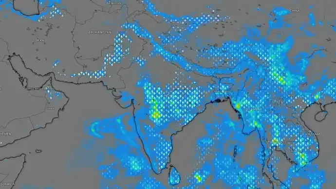
New Delhi: India's southwest monsoon is showing no signs of weakening just yet. Weather conditions remain favourable for widespread rainfall, with a new low-pressure area expected to form over the northwest Bay of Bengal around August 12, according to the latest meteorological update.
The developing system is expected to inject fresh momentum into the monsoon, bringing heavy to very heavy rainfall across several parts of the country over the coming days, particularly eastern and central India.
The development comes even as meteorologists continue to monitor the emerging El Niño conditions, which are generally associated with weaker monsoon activity over the Indian subcontinent.
New Low-Pressure System Likely Over Bay of Bengal
An upper-air cyclonic circulation currently persists over the northwest Bay of Bengal and adjoining regions, extending into the middle levels of the atmosphere.
Under its influence, a low-pressure area is likely to form around August 12, which could strengthen monsoon currents and sustain widespread rainfall as it gradually moves inland.
Weather experts say this system may become one of the key drivers of monsoon activity during the second half of August.
Odisha Likely to Receive Heavy Rainfall
The India Meteorological Department (IMD) has forecast heavy to very heavy rainfall over Odisha between August 12 and August 14, with the developing Bay of Bengal system expected to be the primary trigger.
As the system advances inland, rainfall activity is also likely to expand across parts of:
- Odisha
- Jharkhand
- West Bengal
- Chhattisgarh
- Madhya Pradesh
- Eastern Uttar Pradesh
- Bihar
Rainfall intensity and distribution will depend on the eventual strength and movement of the low-pressure system.
Active Monsoon Trough Supporting Rainfall
Apart from the developing weather system, the monsoon trough remains active and is currently positioned south of its normal location.
This is considered significant because the monsoon trough acts as the primary pathway for rain-bearing systems moving across India.
Its current position favours sustained rainfall across several regions instead of allowing the monsoon to weaken.
Heavy Rain Likely in Himalayan States
The Western Himalayan region is also expected to remain active during the week.
Meteorologists have indicated the possibility of isolated heavy to very heavy rainfall across:
- Himachal Pradesh
- Uttarakhand
- Jammu & Kashmir
Such rainfall could increase the risk of:
- Flash floods
- Landslides
- Waterlogging in vulnerable areas
- Travel disruptions in hilly regions
Residents and travellers have been advised to monitor local weather advisories.
Shear Zone Adding More Atmospheric Instability
Another weather feature contributing to the active monsoon is a shear zone extending across central and adjoining north Peninsular India.
The system stretches through the lower and middle levels of the atmosphere while tilting southward with height, enhancing:
- Moisture convergence
- Atmospheric instability
- Thunderstorm development
- Rain-bearing cloud formation
Combined with the active monsoon trough and the Bay of Bengal disturbance, the shear zone is expected to support continued rainfall across large parts of the country.
El Niño Concerns Remain, But Monsoon Holds Strong
Although global climate indicators continue to point toward the gradual development of El Niño, its impact has not yet significantly weakened India's monsoon circulation.
Instead, successive low-pressure systems forming over the Bay of Bengal have continued to replenish moisture and maintain rainfall activity across much of the country.
Meteorologists say the coming days will be crucial in determining whether the expected low-pressure area develops as forecast and how much rainfall it ultimately delivers.
What to Expect in the Coming Days
Weather experts expect the Bay of Bengal to remain the primary focus for monsoon activity this week. If the low-pressure area strengthens as anticipated, it could sustain widespread rainfall over eastern, central and parts of northern India despite longer-term concerns surrounding El Niño.
Residents in rainfall-prone regions are advised to stay updated with IMD forecasts and local weather advisories as conditions evolve.


Conversation
Be kind and stay on topic. Comments are moderated; abuse, spam and personal attacks are removed. Report a problem