



The southwest monsoon is expected to remain active across large parts of central, eastern and northern India over the coming week, bringing moderate to heavy rainfall to several states, including Uttar Pradesh, Madhya Pradesh, Bihar, Jharkhand, West Bengal, Uttarakhand and the northeastern region.
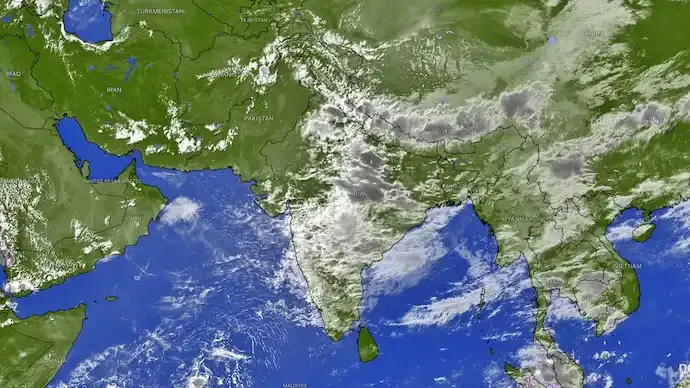
Recent satellite images indicate extensive cloud development across central and eastern India, pointing towards continued monsoon activity. At the same time, a contrasting weather pattern is emerging over northwest and western India, where a large intrusion of dry air is limiting cloud formation and reducing thunderstorm activity.
The latest rainfall outlook suggests that Uttar Pradesh, Madhya Pradesh, Chhattisgarh, Bihar, Jharkhand, Odisha, Uttarakhand and several northeastern states could experience moderate to heavy rain over the next 48 hours. Favourable moisture and atmospheric conditions are expected to support widespread cloud formation and thunderstorms across these regions.

Uttar Pradesh and Madhya Pradesh may witness repeated spells of rainfall in the coming days, which could improve seasonal rainfall levels in areas that have experienced uneven monsoon activity. Bihar, Jharkhand and West Bengal are also likely to remain under the influence of an active monsoon system, while Uttarakhand and the northeastern states may continue to receive frequent rain.
In contrast, northwest India is witnessing the growing influence of dry air. Rajasthan, Gujarat, Punjab, Haryana and Jammu and Kashmir are among the regions likely to be affected, with the dry-air pattern also extending towards Maharashtra and the adjoining Arabian Sea.
The presence of dry air in the middle layers of the atmosphere can restrict the moisture needed for deep cloud formation. Even when surface conditions support convection, dry air at higher levels can weaken developing thunderstorms or prevent them from developing into major rain-bearing systems.
As a result, large parts of western and northwest India may remain largely dry, with only isolated or brief showers expected in some areas. Parts of Maharashtra, Goa and Karnataka along the west coast could continue to receive occasional rainfall, although widespread and sustained monsoon activity appears less likely at present.
The latest weather pattern highlights a clear monsoon divide across India. While central, eastern and northeastern states are likely to experience another active spell of rainfall, dry air is expected to dominate weather conditions across much of northwest and parts of western India.
Over the coming week, monsoon activity is expected to remain concentrated over Uttar Pradesh, Madhya Pradesh, Bihar, Jharkhand, West Bengal, Uttarakhand and the northeastern states, while other regions may wait for atmospheric conditions to become more favourable for widespread rainfall.





Conversation
Be kind and stay on topic. Comments are moderated; abuse, spam and personal attacks are removed. Report a problem