



Large parts of North and Northwest India are expected to witness a temporary pause in monsoon rainfall as strong northwesterly winds bring drier weather conditions across the region.
The changing weather pattern is likely to result in clearer skies, reduced rainfall and rising daytime temperatures over the next several days. Delhi-NCR, Punjab, Haryana, Rajasthan, Madhya Pradesh, Gujarat and parts of northwest Uttar Pradesh are expected to experience largely dry weather for around five to six days.
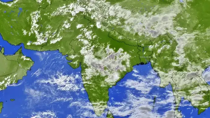
The shift comes after a period of widespread monsoon activity across several parts of northern India. Satellite observations have shown relatively clear conditions over large parts of Northwest and Central India, indicating a significant transition in the weather pattern.

Bareilly in Uttar Pradesh recently experienced an exceptionally intense spell of rainfall, recording 381 mm of rain in the 24 hours ending at 8:30 am, according to weather data cited in the report. The rainfall was reported to have broken the city's all-time highest monthly rainfall record.
However, the arrival of strong northwesterly winds from September 7 is expected to bring drier air into North India and significantly reduce rain activity across a large geographical area.
The decline in cloud cover could bring clear blue skies and stronger sunshine after days of persistent monsoon clouds and rainfall. At the same time, daytime temperatures may rise in several regions despite September marking the later phase of the southwest monsoon season.
Weather conditions across western and central India are expected to remain relatively dry, while more organised cloud systems and rainfall activity could remain concentrated over eastern and northeastern parts of the country.
The break in rainfall may be temporary. Weather projections indicate that another low-pressure system could develop over the Bay of Bengal and influence weather across East, Central and North India between September 12 and September 18.
If the system develops as expected, it could bring another spell of widespread rainfall to several parts of the country and potentially become one of the final significant monsoon phases over northern India before the seasonal withdrawal begins.
For the next few days, however, much of North India is likely to experience a weather reset as rain clouds give way to dry northwesterly winds, clear skies, strong sunshine and warmer daytime conditions.







Conversation
Be kind and stay on topic. Comments are moderated; abuse, spam and personal attacks are removed. Report a problem