

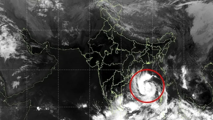

Cyclone Arnab is strengthening over the Bay of Bengal and moving towards the Andhra Pradesh coast, according to the weather information provided in the latest report. Satellite observations have captured the storm’s tightly wound cloud bands and distinct central circulation, highlighting its organised structure.
The India Meteorological Department (IMD) has issued a red-level warning for Andhra Pradesh and adjoining parts of south Odisha, urging heightened preparedness as the cyclone is forecast to intensify.
In its bulletin issued at 5:30 am on October 26, the IMD placed the storm over the east-central and adjoining west-central Bay of Bengal, near latitude 15.4°N and longitude 88.9°E. It was approximately 610 km southeast of Gopalpur in Odisha and 650 km east-southeast of Visakhapatnam in Andhra Pradesh.

The system had moved westwards at around 15 kmph over the preceding six hours after intensifying from a deep depression into a cyclonic storm.
Cyclone Arnab Landfall Forecast and Wind Speeds
According to the forecast cited in the report, Cyclone Arnab is expected to intensify into a severe cyclonic storm by midnight on October 26 and potentially become a very severe cyclonic storm on October 27.
The storm is forecast to cross the Andhra Pradesh and Yanam coasts between Bapatla and Visakhapatnam, close to Yanam, by the forenoon of October 28.
At landfall, maximum sustained wind speeds are expected to reach 115–125 kmph, with gusts potentially touching 140 kmph. The system is likely to move west-northwestwards before turning northwestwards towards the coast.
Red Alert Signals Need for Coastal Preparedness
The forecast wind speeds could threaten power lines, trees, temporary structures and coastal infrastructure. Rough seas, heavy rainfall and disruptions to fishing and maritime activities may also pose risks in affected areas.
Residents in potentially vulnerable districts should monitor official weather bulletins and follow instructions issued by local authorities, including evacuation advisories where applicable.
The eventual impact will depend on the cyclone’s track, intensity and conditions at landfall. Updated satellite observations and IMD forecasts will remain important for tracking its movement and assessing risks to coastal communities.






Conversation
Be kind and stay on topic. Comments are moderated; abuse, spam and personal attacks are removed. Report a problem