

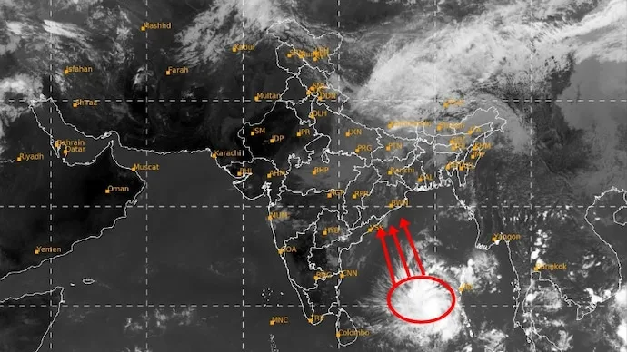

A new weather system over the Bay of Bengal is showing signs of development just days after Cyclone Arnab moved away from India's eastern coast. Satellite observations from India's INSAT-3DS weather satellite have captured an organised cloud formation accompanied by intense thunderstorms over the southeast Bay of Bengal and adjoining areas of the Andaman and Nicobar Islands.
The images captured on Saturday morning, October 31, indicate that the system is still developing. The India Meteorological Department (IMD) is monitoring its movement and expects it to intensify into a depression around October 31 before moving towards the Andhra Pradesh coast.
What Did ISRO's Satellite Capture?
The INSAT-3DS observations show scattered to broken cloud cover, with pockets of intense to very intense thunderstorm activity across the southeast Bay of Bengal.

The system initially developed as a low-pressure area over the South Andaman Sea and adjoining areas of the Andaman and Nicobar Islands on October 29. It subsequently moved west-northwestwards towards the southeast Bay of Bengal.
According to the IMD's forecast, the system is likely to concentrate into a depression around October 31. It is then expected to continue moving west-northwestwards towards the Andhra Pradesh coast over the following two days.
A depression is a more organised stage of a weather system than a low-pressure area, generally associated with stronger winds and thunderstorms. However, the latest satellite bulletin has identified a vortex and does not confirm that the system has officially intensified into a depression.
Rain and Thunderstorms Expected Along the East Coast
The developing system is expected to influence weather conditions over the Andaman Sea and parts of the Bay of Bengal in the coming days.
The IMD's sea-area forecast indicates widespread rainfall and thunderstorms over the South Andaman Sea, with isolated heavy spells. Similar weather activity is expected over the North Andaman Sea.
Along the Andhra Pradesh coast, scattered rainfall and thunderstorms have been forecast. Winds may also strengthen during thunderstorm activity.
The latest coastal bulletin did not carry any port warnings or storm-surge advisories.
New System Develops After Cyclone Arnab
While the remnants of Cyclone Arnab continue to weaken over land, the new weather system is building over the Bay of Bengal.
Its eventual intensity and movement remain under observation. Further satellite imagery and meteorological data will help the IMD assess whether it develops into a depression and how it may influence weather conditions along India's eastern coastline.
Official website: India Meteorological Department






Conversation
Be kind and stay on topic. Comments are moderated; abuse, spam and personal attacks are removed. Report a problem