

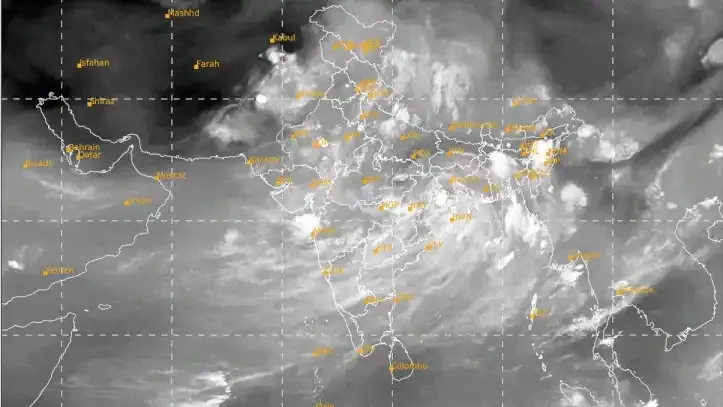

Fresh satellite imagery from ISRO's INSAT-3DR and INSAT-3DS weather satellites has captured an extensive blanket of monsoon clouds covering almost the entire Indian subcontinent, highlighting the widespread influence of the southwest monsoon.
The images, recorded during the early hours of July 22, provide meteorologists with valuable insights into cloud development, atmospheric moisture, and rainfall patterns across the country.
According to the India Meteorological Department (IMD), active monsoon conditions are expected to continue in several regions over the coming days, although rainfall distribution is likely to vary across the country.

What the INSAT Satellite Images Reveal
The thermal infrared imagery captured by the INSAT satellites during the night shows an extensive cloud band stretching across large parts of India.
The cloud system extends from:
- The northern Bay of Bengal
- Odisha
- Chhattisgarh
- Madhya Pradesh
- Gujarat
- Arabian Sea
Only a few regions, including parts of western Rajasthan and Kutch, appear relatively free from dense cloud cover.
Thermal infrared imaging enables satellites to observe cloud structures even during nighttime by detecting heat instead of visible light.
Moisture Levels Remain High
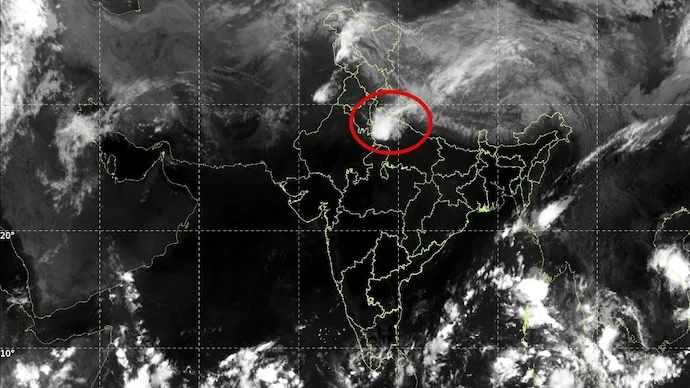
Water vapour imagery released by the IMD indicates that the atmosphere remains rich in moisture across much of the country.
Meteorologists say abundant atmospheric moisture supports the continuous development of rain-bearing clouds and helps sustain active monsoon conditions over multiple days rather than isolated rainfall events.
Why Cloud Top Temperature Matters
One of the most significant indicators used by weather scientists is cloud top brightness temperature.
As clouds rise higher into the atmosphere, temperatures at their tops become colder.
Satellite observations showing cloud-top temperatures below –60°C, and in some places below –80°C, indicate the presence of extremely tall thunderstorm clouds reaching heights of approximately 12 to 16 kilometres.
These towering cumulonimbus clouds are capable of producing:
- Intense rainfall
- Thunderstorms
- Lightning
- Strong wind activity
Such cloud formations are commonly associated with heavy monsoon precipitation.
Current Position of the Monsoon Trough
The IMD has reported that the monsoon trough—the elongated low-pressure zone that strongly influences rainfall across northern India—is currently positioned close to its normal location.
Several cyclonic circulations have also been identified over regions including:
- Punjab
- Southern Uttar Pradesh
- Bihar–Jharkhand region
- Southwest Rajasthan
- Assam
In addition, a mid-level atmospheric trough extends from the west-central Bay of Bengal to the northeastern Arabian Sea, supporting the widespread cloud formation observed in satellite imagery.
What to Expect in the Coming Days
According to the latest IMD forecast:
- Northwest India is likely to experience active monsoon conditions over the next four to five days.
- Northeast India is also expected to receive significant rainfall.
- Rainfall activity may remain comparatively subdued across parts of west-central India and southern peninsular India during the same period.
Residents in areas expecting heavy rainfall are advised to monitor official weather updates and follow local advisories.
Does This End India's Rainfall Deficit?
Despite the widespread cloud cover, meteorologists caution that one active monsoon phase alone is unlikely to eliminate the seasonal rainfall deficit.
India experienced significantly below-normal rainfall during June 2026, making it one of the driest Junes in recent decades.
Although the current cloud pattern indicates an active spell of the southwest monsoon, seasonal rainfall recovery will depend on sustained precipitation over the remainder of the monsoon period.
Key Highlights
- ISRO's INSAT satellites captured widespread monsoon cloud cover across nearly all of India.
- Thermal infrared imagery shows an extensive cloud band stretching from the Bay of Bengal to the Arabian Sea.
- Extremely cold cloud-top temperatures indicate the presence of tall thunderstorm systems capable of heavy rainfall.
- The IMD says the monsoon trough remains close to its normal position.
- Active rainfall is expected over northwest and northeast India during the next few days.
- Meteorologists say additional rainfall will be needed to reduce the seasonal rainfall deficit.
Frequently Asked Questions (FAQs)
What do the latest ISRO satellite images show?
The INSAT-3DR and INSAT-3DS satellites show widespread monsoon clouds covering most parts of India during the early hours of July 22.
Why are cloud-top temperatures important?
Very cold cloud-top temperatures indicate tall thunderstorm clouds, which are generally associated with heavy rainfall and strong convective activity.
What is the monsoon trough?
The monsoon trough is a low-pressure belt extending across northern India that plays a key role in determining the distribution and intensity of monsoon rainfall.
Which regions are expected to receive more rainfall?
According to the IMD, northwest and northeast India are expected to witness active monsoon conditions over the next four to five days.
Will the current monsoon spell eliminate India's rainfall deficit?
Not immediately. While the present cloud cover indicates an active monsoon phase, sustained rainfall over a longer period will be required to significantly reduce the seasonal deficit.
Which satellites captured these images?
The observations were made using ISRO's INSAT-3DR and INSAT-3DS meteorological satellites.






Conversation
Be kind and stay on topic. Comments are moderated; abuse, spam and personal attacks are removed. Report a problem