


The Delhi-NCR rain episode brought heavy showers, thunderstorms and gusty winds across the region on Monday, October 12, following overnight rain and strong winds that began late Sunday. Delhi, Gurugram, Noida, Faridabad and Ghaziabad experienced a sharp change in weather as an active Western Disturbance affected parts of northwest India.
According to the rainfall data provided, Safdarjung, Delhi’s primary weather observatory, recorded 40 mm of rain up to 5:30 am. The India Meteorological Department (IMD) had warned of heavy rain, thunderstorms and gusty winds across parts of the region despite the withdrawal of the southwest monsoon from several areas.
What Does the Satellite Image Show?
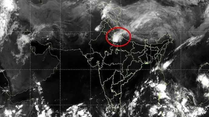
An INSAT-3DS thermal infrared image captured between 8:30 am and 8:57 am on Monday showed extensive cloud cover over northern India. A broad band of clouds stretched across parts of the Himalayan region and adjoining plains.

Brighter white areas in infrared satellite imagery generally indicate colder cloud tops, which can be associated with high, deep clouds capable of producing thunderstorms. However, the image alone cannot establish the intensity of rainfall at a specific location.
The cloud pattern was consistent with an active weather system affecting northwest India, with rain-bearing clouds extending towards Delhi-NCR.
Western Disturbance Behind Delhi-NCR Rain
A Western Disturbance is a weather system that travels eastwards from the west and can bring rain, thunderstorms and, in some conditions, hail to northwestern India.
According to the IMD bulletin dated October 11, a Western Disturbance was present as a cyclonic circulation over Himachal Pradesh. Additional atmospheric troughs extended from northwest Rajasthan towards northeast Madhya Pradesh, while another connected a circulation over central Pakistan with north Madhya Pradesh.
These atmospheric features can encourage air to rise. When sufficient moisture and instability are present, this upward movement supports cloud formation and thunderstorm development.
Fresh cloud bands extending from central Haryana were also helping sustain showers over the plains. As these bands moved across the region, different parts of Delhi, Gurugram, Noida, Faridabad and Ghaziabad experienced varying spells of rainfall.
Will the Rain Continue?
The IMD issued a warning for heavy rain, thunderstorms and gusty winds over Delhi on Monday morning. Orange warnings also covered several adjoining districts in Haryana and Uttar Pradesh, according to the information provided.
Such conditions can lead to waterlogging, traffic disruption and reduced visibility, particularly during periods of intense rainfall.
The episode highlights why rain can continue even after the southwest monsoon withdraws. Western Disturbances and other atmospheric systems can trigger significant rainfall during the post-monsoon period.
The current Delhi-NCR downpour is linked to these weather disturbances rather than a return of the southwest monsoon. Residents should follow official IMD updates for changing forecasts and local weather warnings.







Conversation
Be kind and stay on topic. Comments are moderated; abuse, spam and personal attacks are removed. Report a problem